Where to Go
Following are maps to help you find your way around the Lahontan Valley Wetland birding hotspots!
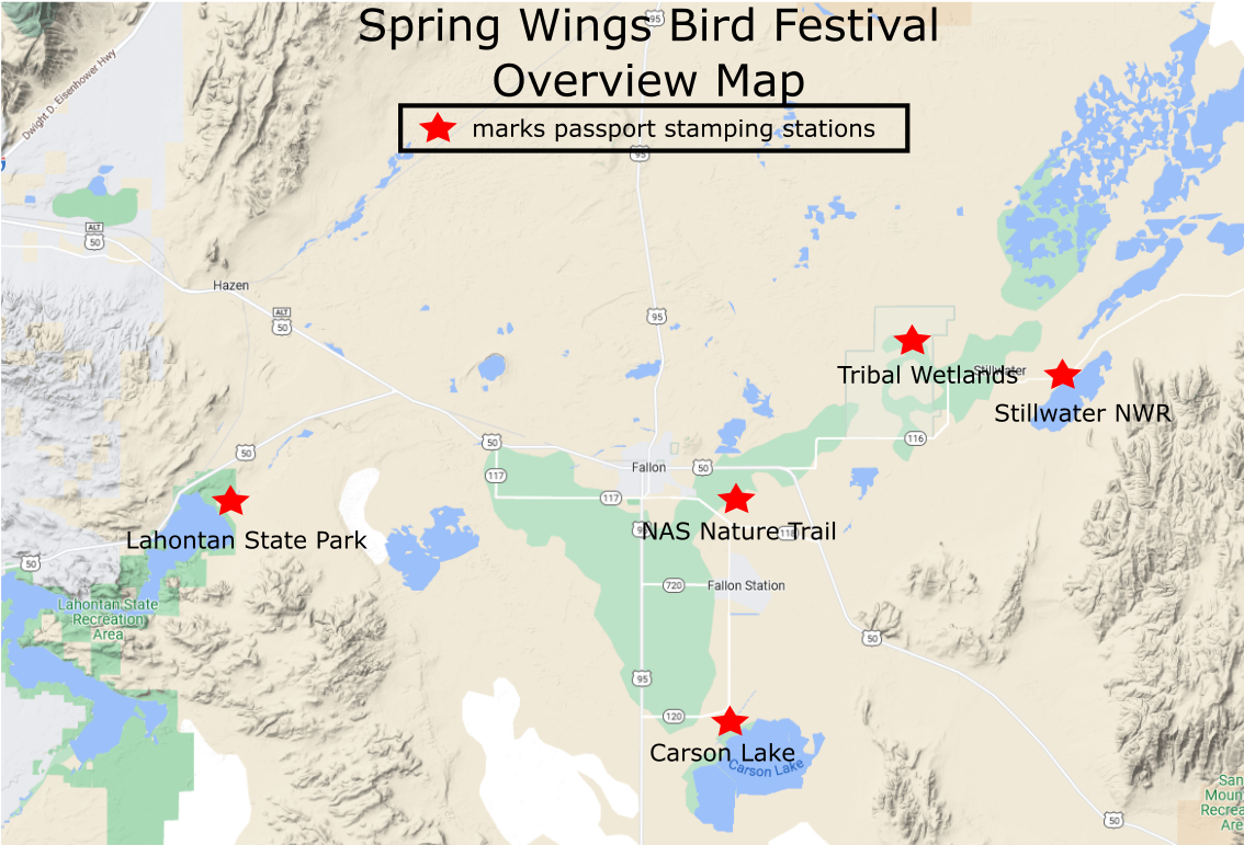
Map of Spring Wings Bird Festival Passport locations
Directions to Sites (click on site name to open a Google Map)
Lahontan State Park - From the corner of Williams Ave (Hwy 50) and Maine Street in Fallon, head west on Hwy 50 for 9.3 miles. Turn left to stay on Hwy 50 and drive 7.1 miles. Turn left to merge onto Cadet Road. At about 0.5 miles, bear right onto Lahontan Dam Road. Follow this road another 0.5 miles to the park entrance kiosk.
From Fernley, head east on Hwy 50 Alt for 13 miles. Turn right onto Bench Road and drive 2.3 miles. Turn right onto Hwy 50 and drive 4.4 miles. Turn left onto Cadet Road and bear right onto Lahontan Dam Road to the park entrance.
Fallon Naval Air Station Nature Trail - From the corner of Williams Ave (Hwy 50) and Maine Street in Fallon, head east on Hwy 50 out of Fallon. At 2.2 miles, turn right onto Crook Road. Follow Crook Road 1.4 miles and just before you reach the Wildes Road intersection, and staying north of the ditch, turn left (east) into the parking area. Look for the trail marker. See zoomed in map for a better view of the road.
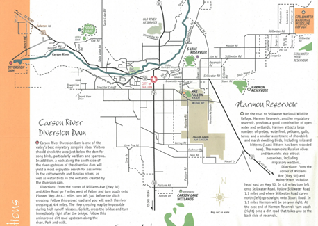
Carson Lake and Pasture - From the corner of Williams Ave (Hwy 50) and Taylor Street (Hwy 95) in Fallon, go 8.8 miles south to Pasture Road. Turn east (left) on Pasture Road and go 2 miles to an entrance marked with a “Greenhead Hunting Club" sign. See map below. Water is low this year, so please check in at Oats Park or the Carson Lake Passport Station for directions to open water in this area (mostly around York Unit on the map).
Alert: Vehicle access to the Carson Lake Wildlife Management Area will be closed May 11, 2023, due to flooding and safety concerns until further notice. Walk-in access is still permitted. We will continue to monitor and manage flooding and public safety concerns and will notify the public when vehicle access is re-opened. The Carson Basin snow water equivalent peaked at 283% of normal median in 2023. As of May 1, the snow water equivalent remaining in the Carson Basin was 83%, so we anticipate flooding and public safety concerns to persist for the foreseeable future. Please see web site reference below
https://www.ndow.org/discover-your-public-land/
Fallon Paiute Shoshone Tribal Wetlands - From the corner of Williams Ave (Hwy 50) and Maine Street in Fallon, go east on Hwy 50 for 4.6 miles then turn left on Stillwater Road (State Route 116) by Harmon Junction. Go 5.0 miles on SR 116 and turn left on Agency Road. Go 3.0 miles to the end of Agency Road and you're at the entrance to the wetlands. The roads are easily passable by passenger vehicle.
Stillwater National Wildlife Refuge - From the corner of Williams Ave (Hwy 50) and Maine Street in Fallon, head east on Hwy 50 out of Fallon. At 4.6 miles, turn left onto Stillwater Road (State Route 116). For the new refuge office, follow Stillwater Road 10 miles to the corner of Stillwater Road and Freeman Lane. It’s the cream colored house with green trim. Keep going another two miles and you’ll come to a sign marking the entrance to the refuge.
Lahontan State Park - From the corner of Williams Ave (Hwy 50) and Maine Street in Fallon, head west on Hwy 50 for 9.3 miles. Turn left to stay on Hwy 50 and drive 7.1 miles. Turn left to merge onto Cadet Road. At about 0.5 miles, bear right onto Lahontan Dam Road. Follow this road another 0.5 miles to the park entrance kiosk.
From Fernley, head east on Hwy 50 Alt for 13 miles. Turn right onto Bench Road and drive 2.3 miles. Turn right onto Hwy 50 and drive 4.4 miles. Turn left onto Cadet Road and bear right onto Lahontan Dam Road to the park entrance.
Fallon Naval Air Station Nature Trail - From the corner of Williams Ave (Hwy 50) and Maine Street in Fallon, head east on Hwy 50 out of Fallon. At 2.2 miles, turn right onto Crook Road. Follow Crook Road 1.4 miles and just before you reach the Wildes Road intersection, and staying north of the ditch, turn left (east) into the parking area. Look for the trail marker. See zoomed in map for a better view of the road.
Carson Lake and Pasture - From the corner of Williams Ave (Hwy 50) and Taylor Street (Hwy 95) in Fallon, go 8.8 miles south to Pasture Road. Turn east (left) on Pasture Road and go 2 miles to an entrance marked with a “Greenhead Hunting Club" sign. See map below. Water is low this year, so please check in at Oats Park or the Carson Lake Passport Station for directions to open water in this area (mostly around York Unit on the map).
Alert: Vehicle access to the Carson Lake Wildlife Management Area will be closed May 11, 2023, due to flooding and safety concerns until further notice. Walk-in access is still permitted. We will continue to monitor and manage flooding and public safety concerns and will notify the public when vehicle access is re-opened. The Carson Basin snow water equivalent peaked at 283% of normal median in 2023. As of May 1, the snow water equivalent remaining in the Carson Basin was 83%, so we anticipate flooding and public safety concerns to persist for the foreseeable future. Please see web site reference below
https://www.ndow.org/discover-your-public-land/
Fallon Paiute Shoshone Tribal Wetlands - From the corner of Williams Ave (Hwy 50) and Maine Street in Fallon, go east on Hwy 50 for 4.6 miles then turn left on Stillwater Road (State Route 116) by Harmon Junction. Go 5.0 miles on SR 116 and turn left on Agency Road. Go 3.0 miles to the end of Agency Road and you're at the entrance to the wetlands. The roads are easily passable by passenger vehicle.
Stillwater National Wildlife Refuge - From the corner of Williams Ave (Hwy 50) and Maine Street in Fallon, head east on Hwy 50 out of Fallon. At 4.6 miles, turn left onto Stillwater Road (State Route 116). For the new refuge office, follow Stillwater Road 10 miles to the corner of Stillwater Road and Freeman Lane. It’s the cream colored house with green trim. Keep going another two miles and you’ll come to a sign marking the entrance to the refuge.
Click on the maps below for better viewing.
Overview map and directions to local birding hotspots.
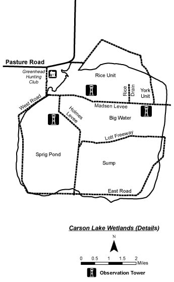
Map of the dirt roads around Carson Lake.
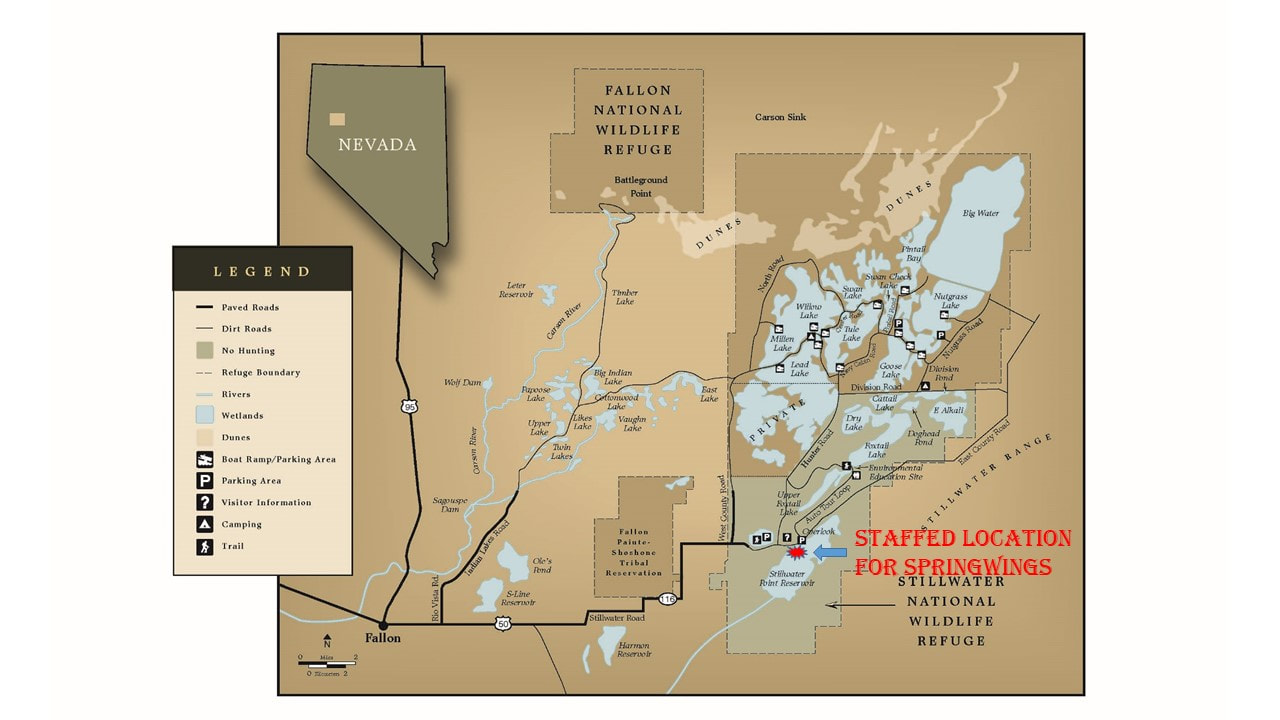
Map of the Stillwater National Wildlife Refuge. The red star marks the point to get your passport stamp!
More maps coming soon!
Places to Eat! Check out the local restaurants!
And places to grab some rest after a long day of birding!